
7-Day Rwenzori Mountains Central Circuit Trek to Margherita Peak, Uganda

7 Days 6 Nights

A Rwenzori trek Margherita Peak 7 days via the Central Circuit Trail — ascending Africa's third-highest summit at 5,109 metres through Uganda's UNESCO World Heritage mountain range, traversing unique Afro-alpine vegetation zones, glacial bogs, and active glaciers on Mount Stanley.

  • 70
  • ot included — required; must cover high-altitude trekking (to 5,109m), mountaineering, emergency medical evacuation, and trip interruption
  • December – February and June – August (drier months — clearer summit conditions, more stable weather); trek is possible year-round — the Rwenzori receives rainfall in all months
  • Not included — see Excludes for Kampala-to-Kasese transport options
  • 4–7+ hours per day depending on stage (see itinerary); Day 5 summit day: 7+ hours

Overview

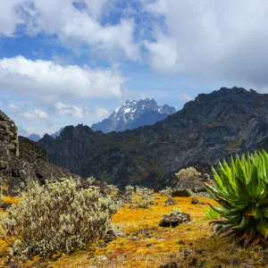
The Rwenzori Mountains — known since Ptolemy's second-century geography as the "Mountains of the Moon" and believed to be the source of the Nile — rise on Uganda's western border with the Democratic Republic of Congo, forming one of Africa's most extraordinary and least-visited alpine environments. Unlike the volcanic mountains of Kilimanjaro and Mount Kenya, the Rwenzori is a block mountain range, geologically ancient and perpetually wet, supporting a sequence of vegetation zones found nowhere else on Earth: from lowland tropical forest through bamboo groves and giant heather woodland, into the alien landscape of the Afro-alpine zone where giant groundsel trees (Dendrosenecio elgonensis) grow three metres tall and giant lobelia (Lobelia bequaertii) sends purple flower spikes skyward from rosette bases in the bogs.

This 7-day Central Circuit Trek summits Margherita Peak on Mount Stanley — at 5,109 metres, Africa's third-highest point after Kilimanjaro (5,895m) and Batian on Mount Kenya (5,199m). The route follows the most established line on the Rwenzori: beginning at Mihunga Gate (1,615m) in the park's southeast and climbing through progressive altitude bands to Elena Hut (4,541m), the glacier camp from which the summit push departs before dawn on Day 5. The return descends via Kitandara Lake, the Fresh Field Pass, and the historic Bujongolo rock shelter — the base camp of Luigi Amedeo, Duke of Abruzzi, during his 1906 first ascent of Margherita Peak.

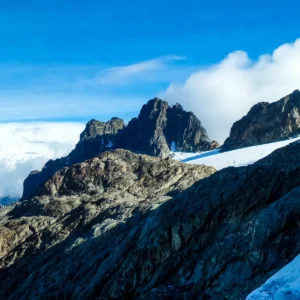
The summit day is not a walk. The route from Elena Hut to Margherita Peak traverses the Stanley Plateau glacier with crampon and ice axe, requiring experience on glaciated terrain. UWA has constructed a bridge across the principal crevasse on the glacier approach — a permanent safety enhancement that has made the route safer than at any point since the 1990s. Technical ropes are fixed at key sections. All summiting equipment (crampons, ice axe, harness, ropes) is provided by the operator.

The Rwenzori Central Circuit is not primarily a summit climb — it is one of Africa's great mountain wilderness experiences, with each day passing through vegetation zones that have no equivalent elsewhere on the continent, beside rivers and waterfalls, and with the possibility of encountering chimpanzees, black and white colobus monkeys, blue monkeys, and the brilliant Rwenzori Turaco in the lower forest zones.

Trip Highlights

  • Summit Margherita Peak (5,109m) — Africa's third-highest point — via the Stanley Plateau glacier
  • Trek through the Rwenzori's extraordinary Afro-alpine vegetation: giant groundsel trees, giant lobelia bog forests, and heather woodland found nowhere else on Earth
  • Traverse Bigo Bog and Bujuku Lake — some of the Rwenzori's most dramatic and alien high-altitude landscapes
  • See chimpanzees, black and white colobus monkeys, blue monkeys, and the Rwenzori Turaco in the lower forest zones on Day 1
  • Cross the Scott-Elliott Pass (4,372m) on the approach to Elena Hut
  • Descend past Bujongolo — the 1906 base camp of the Duke of Abruzzi, first summiteer of Margherita Peak
  • Rwenzori Mountains National Park is a UNESCO World Heritage Site covering approximately 998 km² of endemic biodiversity
  • All park fees, guide, chef, porters, hut accommodation, and summiting equipment included

Your 7-Day Rwenzori Central Circuit Trek to Margherita Peak

  • Day
    01

    Mihunga Gate (1,615m) to Nyabitaba Hut (2,651m)

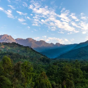
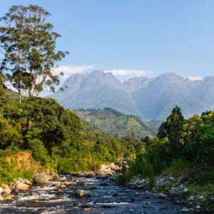
    Meet your guide, chef, and porters at Mihunga Gate for equipment check, orientation, and registration with UWA. Begin the trek through lowland tropical forest — the Rwenzori's lower slopes hold significant primate and bird diversity. Chimpanzees are present in this forest zone (sightings are possible but not guaranteed). Black and white colobus monkeys, blue monkeys, and the Rwenzori Turaco — a brilliantly coloured endemic forest bird — are reliably seen or heard in the canopy. The trail crosses rivers and passes several waterfalls before climbing steadily to Nyabitaba Hut, a timber hut on a ridge with views over the Mubuku and Bujuku valleys. Portal Peaks (4,626m) is visible to the northwest on a clear day.

  • Day
    02

    Nyabitaba Hut (2,651m) to John Matte Hut (3,380m)

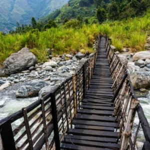
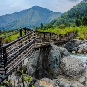
    Descend from Nyabitaba to cross the Mubuku River (at approximately 2,600m) — in good conditions a log bridge; in flood the river requires care. The trail enters the giant heather zone: tree heather (Erica arborea) shrouded in moss and lichen grows several metres high, draped with old man's beard. The first lobelia plants appear in the bogs. Giant groundsel trees begin to emerge as the trail gains altitude. The vegetation here is found in an unbroken sequence only in the Rwenzori — nowhere else in Africa is the Afro-alpine zone this intact and this dense. Arrive at John Matte Hut in the afternoon — a wooden hut at 3,380m with views of the Bujuku Valley ahead.

  • Day
    03

    John Matte Hut (3,380m) to Bujuku Hut (3,977m)

    Descend from the hut to cross the Bujuku River and enter the Lower Bigo Bog — one of the most distinctive and otherworldly sections of the entire trek. Giant lobelias (Lobelia bequaertii) stand from the bog floor, sending purple flower spikes up to two metres above their rosette bases. The bog requires careful navigation — the surface can swallow a boot to the knee. The trail rises through the Upper Bigo Bog and emerges at Bujuku Lake (3,977m) — a glacial lake reflecting the surrounding peaks on a clear morning. To the south: Mount Baker. To the west: Mount Stanley. Bujuku Hut sits on the lake's eastern shore with dramatic views of the alpine environment on all sides.

  • Day
    04

    Bujuku Hut (3,977m) to Elena Hut (4,541m)

    The most critical acclimatisation day of the trek. Depart Bujuku and climb through continuing bog terrain and the Groundsel Gully — a steep ascent through a dense stand of giant groundsel trees whose forms become increasingly surreal as altitude increases. The trail uses a metal ladder to surmount a particularly steep section near the top of the gully before reaching the Scott-Elliott Pass at 4,372m — a col between Mount Baker to the south and Mount Stanley to the west, with views into both the Uganda and DRC sides of the range. From the pass, the trail continues to Elena Hut at 4,541m — a metal shelter at the base of the Stanley Glacier. Prepare equipment and clothing for the summit attempt: crampons, ice axe, harness, and all warmth layers. Sleep early.

  • Day
    05

    Elena Hut (4,541m) — Margherita Peak (5,109m) — Kitandara Hut (4,027m)

    This is a technical glacier day — the most physically and mentally demanding stage of the trek. Pre-dawn departure (typically 4:00–5:00 a.m.) is essential to reach the glacier in firm conditions before the ice softens. Rope up with your guide at the glacier edge and traverse the Stanley Plateau — a permanent ice field at over 5,000m — crossing a crevasse bridge constructed by UWA in cooperation with partners. Fixed ropes assist passage through the steepest sections. The summit of Margherita Peak (5,109m) — Africa's third-highest point — is reached after a final steep snow and ice approach. On a clear day, the summit view extends across the DRC to the west, the Albertine Rift to the east, and the full Rwenzori range in both directions. Descend the glacier, return to Elena Hut for lunch and equipment removal, then make the long descent southwest past Kitandara Lake — a glacially formed lake at 4,027m in a deep valley — to Kitandara Hut for dinner and overnight.

  • Day
    06

    Kitandara Hut (4,027m) — Fresh Field Pass (4,282m) — Guy Yeoman Hut (3,450m)

    Ascend from Kitandara to the Fresh Field Pass (4,282m) — a col that opens views west into the Democratic Republic of Congo and northwest toward Mount Stanley. Descend the eastern side of the pass and follow the trail past Bujongolo — a massive rock shelter in the valley that served as the base camp for Luigi Amedeo, Duke of Abruzzi, during his historic 1906 first ascent of Margherita Peak. The site is still recognisable from photographs taken during that expedition. Continue down to Guy Yeoman Hut (3,450m) for dinner and a final mountain overnight.

  • Day
    07

    Guy Yeoman Hut (3,450m) — Nyabitaba Hut (2,651m) — Mihunga Gate (1,615m)

    The final descent follows the northern ridgeline back toward Nyabitaba Hut — a 3–4 hour morning descent through the giant heather and forest zones to the hut for a lunch break. Continue the final 3-hour descent through the lower tropical forest to Mihunga Gate and the park boundary at 1,615m. Receive your summit certificate from the RMS office and attend any community celebration at the gate. Your driver-guide transfers you to your next destination.

The Cost Includes

  • UWA park entrance fee — USD 35/person/day × 7 days = USD 245/person (non-refundable once paid)
  • Certified RMS mountain guide throughout
  • Trek chef — all meals prepared at the huts (full board)
  • 2 porters per trekker (carrying operator equipment and food; max 25 kg per porter)
  • 6 nights' hut accommodation on the Central Circuit:
  • All summiting technical equipment: crampons, ice axe, harness, fixed ropes, rubber boots
  • Bottled drinking water throughout
  • Summit certificate on successful completion

The Cost Excludes

  • Uganda eVisa — apply at immigration.go.ug before travel
  • Yellow fever vaccination certificate — mandatory for Uganda entry; carry your International Certificate of Vaccination (yellow booklet)
  • Comprehensive travel insurance — required; must specifically cover high-altitude mountaineering (to 5,109m), glacier travel, emergency medical evacuation, and trip interruption. Confirm coverage altitude with your insurer before travel.
  • Personal warm gear: sleeping bag (-10°C minimum), insulated jacket, waterproof gloves, gaiters, trekking poles, headlamp, hiking boots (waterproof, ankle-support), and wool or synthetic base layers — see full What to Bring list below
  • Personal items, medications (including any altitude medication — consult your doctor before departure)
  • Tips and gratuities for guide, chef, and porters (recommended: USD 10–15/person/day for guide, USD 5–7/person/day per porter)
  • Additional day fee if summit attempt requires an extra day (USD 150/day per UWA policy)
  • Additional peak fees if other summits are attempted (USD 100/peak beyond the primary summit)
  • Accommodation in Kasese before and after the trek