
CHOGORIA ROUTE — MOUNT KENYA

6 Days 5 Nights

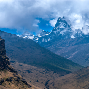
The Chogoria Route Mount Kenya is the most scenic approach to Point Lenana (4,985 m) on
Africa's second-highest peak. Approaching from the mountain's eastern flank via Chogoria town
in Tharaka-Nithi County, this 4-to-6-day route passes glacial lakes, a 200-metre sheer rock
amphitheatre, and some of the mountain's richest wildlife zones. It is universally regarded by
guides and trekkers as the route with the most dramatic and varied landscapes on Mount Kenya.

  • 4,985 m (16,355 ft) — Point Lenana
  • Chogoria Gate / Meru Bandas, eastern slopes — Tharaka-Nithi County
  • Jan–Feb and Jul–Sep (dry; eastern slopes receive more moisture than western)
  • es — KWS park entry permit + climbing permit (via eCitizen)

ROUTE OVERVIEW

The Chogoria Route starts at Chogoria Gate (approx. 2,000 m) on the eastern slopes, in
Tharaka-Nithi County. A 4x4 vehicle is mandatory for the forest track to the road head at the
Meru Bandas (3,000 m) — the track is too rough for standard vehicles. Most itineraries begin
hiking from the Bandas.

From the Meru Bandas, the trail ascends through dense Afromontane forest, passing the Nithi
Falls and fisheries station before reaching the Road Head Camp (3,300 m). The next camp is
Lake Ellis (3,650 m), a tranquil alpine lake set in the Hinde Valley, reached via Mugi Hill.
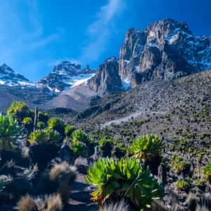
Wildlife — buffalo, elephant, zebra, and colobus — is regularly seen in the forest and lower
moorland zones.

Day three moves from Lake Ellis toward Mintos Hut (4,200 m) along a ridge with aerial views
over the Gorges Valley. The Temple becomes visible in the afternoon — a 150-metre cliff face
surrounding Lake Michaelson. The descent to Lake Michaelson campsite is optional but highly
recommended for those with time.

Summit night begins between 1–3 AM from Mintos Hut. The ascent to Point Lenana (4,985 m)
follows a steep rocky path via the Simba Col. On a clear day, Kilimanjaro is visible from the
summit. Descent is most commonly via the Sirimon or Naro Moru routes, completing the
cross-mountain traverse in 5–6 days total.

ROUTE HIGHLIGHTS

  • Pass through Lake Ellis (3,650 m) and Lake Michaelson (4,100 m) — the two most celebrated alpine lakes on Mount Kenya
  • View the Temple: a 200-metre vertical rock amphitheatre enclosing Lake Michaelson — found on no other route
  • Gorges Valley: a deep glacial corridor with sheer rock walls, unique on the entire mountain
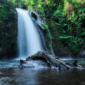
  • Nithi Falls — a multi-tiered waterfall in the forest section, a classic photo stop on the ascent
  • Giant's Billiard Table — a flat volcanic rock formation with panoramic views of the northern moorland
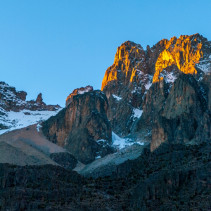
  • Eastern light conditions produce exceptional photography from first light onward throughout the route
  • Combine with Sirimon or Naro Moru descent for the most complete Mount Kenya traverse available

WHAT'S INCLUDED

  • All KWS park entry and climbing permit fees
  • Mountain rescue fee
  • Certified and KWS-licensed mountain guide for the full duration
  • Porters to carry group equipment (up to 15 kg per client load)
  • Full camping equipment — tents, sleeping mats, dining tent, kitchen tent
  • All meals on the mountain
  • Emergency first aid kit and pulse oximeter
  • 4x4 transfer through forest section from Chogoria Gate to Meru Bandas road head
  • Return transfers between Chogoria town / Nanyuki and park gate
  • Summit certificate upon reaching Point Lenana

WHAT'S EXCLUDED

  • International and domestic flights to/from Kenya
  • Visa and eTA fees
  • Personal travel insurance (required — must cover mountain rescue)
  • Tips and gratuities for guides, porters, and crew
  • Personal hiking gear — boots, trekking poles, layers, sleeping bag
  • Altitude medication (Diamox) — consult your doctor before travel
  • Alcoholic beverages and personal purchases
  • Optional fly fishing licence (lakes are stocked with rainbow trout)

Frequently Asked Questions

Why is the Chogoria Route considered the most scenic route on Mount Kenya?

The Chogoria Route passes through the only glacial gorge on the mountain — the Gorges Valley
— and is the sole route that visits Lake Michaelson, enclosed by the 200-metre rock walls of the
Temple. The eastern approach also means better morning light and greater botanical diversity than
the drier western routes.

What is the best time of year to hike the Chogoria Route?

January to February and July to September offer the clearest conditions, though the eastern
slopes receive more moisture year-round than the Sirimon side. Even in dry season, afternoon
cloud build-up is common above 4,000 m. Start summit pushes by 2 AM to maximise clear weather
at the top.

Do I need a 4x4 vehicle for the Chogoria Route?

Yes. The forest track between Chogoria Gate and the Meru Bandas road head is unpaved and
deeply rutted — a standard vehicle cannot manage it. Your TripGenius Travel operator arranges
the 4x4 transfer as part of the trip. This is included in the package cost.

Can I fish at the lakes along the Chogoria Route?

Lake Ellis and Lake Michaelson are stocked with rainbow and brown trout. A fishing licence
from KWS is required and can be arranged in advance through your operator. Carry a lightweight
rod if this interests you — it is a genuine perk unique to this route.

What gear should I bring?

Waterproof outer shell and waterproof boot gaiters are particularly important on this route —
the eastern side is wetter. Layered insulation, trekking boots, poles, headlamp, sleeping bag
rated to -10°C, UV sunglasses, and SPF 50+ sunscreen are all essential. Guides in Chogoria town
can arrange gear rental for sleeping bags and poles.